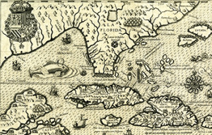
 Both Florida and Cuba have played a central role in the socio-economic development of the Caribbean basin for centuries. What new research and analytical tools can be employed for the study of this time-honored interchange in the age of Digital Humanities? What other physical and theoretical connections can be derived from the visualization of commercial, political, military and intellectual routes between these spaces? At ThatCamp Gainesville I would like to share, discuss and get feedback about these and other core inquiries from this current DH project scheduled for presentation in Hastac2017. Using ArcGIS as our main mapping platform, our finalized product should provide a creative and dynamic contrast between conventional cartographic materials of transportation and communication such as railroads, steamships and telegraphic cables across the Florida Strait, with the literary representation of some of these connections in the works of several Cuban and American writers. Can you help brainstorming? Would you share your digital mapping experience with me?
Meta
-
Recent Posts
Categories
- Collaboration (1)
- Data Mining (1)
- Libraries (1)
- Mapping (2)
- Metadata (1)
- Museums (2)
- Research Methods (1)
- Session Proposals (3)
- Session: Make (2)
- Session: Talk (2)
- Session: Teach (1)
- Teaching (1)
- Text Mining (1)
- Uncategorized (3)
- Visualizations (2)
Twitter
Evaluation


This will be a fantastic session! I hope Carol McAuliffe, Map Librarian, and Jessie English, Cuba Coordinator in the Libraries, can both make this!
Are you on Twitter? It will be great to share the discussion with #CaribbeanDH folks on Twitter!